
Introduction
Territorial extent has always been considered one of the sources of national power. States with greater strategic depth have been able to use this advantage to disperse their strategic assets and infrastructure, thereby reducing their vulnerability to hostile threats. This issue has been well addressed in the context of passive defense measures (Atashjameh, 2024).
However, while territorial extent offers significant advantages, it also has disadvantages. With the emergence of drone warfare, these disadvantages have become more critical. This study seeks to examine this issue based on the experiences of conflicts in air domain, specifically drone warfare in the Persian Gulf region and Ukraine.
Drones
The emergence of drones in warfare, became one of the most significant milestones of modern warfare. While the military use of drone’s history even back to several decades ago such as Iraq-Iran war (Atashjameh, 2026), the Russia–Ukraine War has raised the attentions of drone warfare and became the feature of modern warfare. Drones, due to their low speed and flexible flight profiles are threats hard to detect and intercept by Air and Missile Defense (AMD) networks.
These characteristics make them highly adaptable, enabling them to exploit gaps in AMD coverage and penetrate enemy territory. They can also take advantage of terrain-induced radar limitations, such as flying through mountain passes or at very low altitude over the sea, where radar line-of-sight restrictions and sea-clutter effects (Upton & Thurman, 2000) reduce detection capability.
Russia-Ukraine Case
The Russia–Ukraine war, which began in 2022, became one of the main arenas of drone warfare. The role of drones in this war has raised concerns about the functioning of this weapon in warfare. Both sides deployed drones against each other to strike critical infrastructure. Regardless of the effectiveness and scale of deployment, the significance of this issue lies in the depth and concentration of AMD networks.
While Ukraine has a smaller territorial extent and benefits from a more concentrated AMD network, evidence indicates that, despite intercepting many Russian drones, Russia has successfully targeted Ukraine's critical infrastructure such as energy facilities (Reuters, 2025). At the same time, this also applies to Russia, which, while benefiting from its greater geographical extent that enables the dispersal of strategic assets such as Command and Control (C2) nodes and radar sites deep within the Russian Federation, has also been vulnerable to Ukrainian drone strikes, such as Ukrainian’s claim regarding targeting the Russia’s AMD at Orsk region (Chursina & Safronova, 2024).
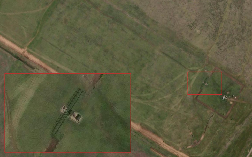
Figure 1: A VHF surveillance AMD node, located southeast of Orenburg-2 Aerodrom Airport, Orenburg Oblast, Russia (Location: 51°41′51.6″N, 55°02′42.8″E). Figure Source: ArcGIs.com
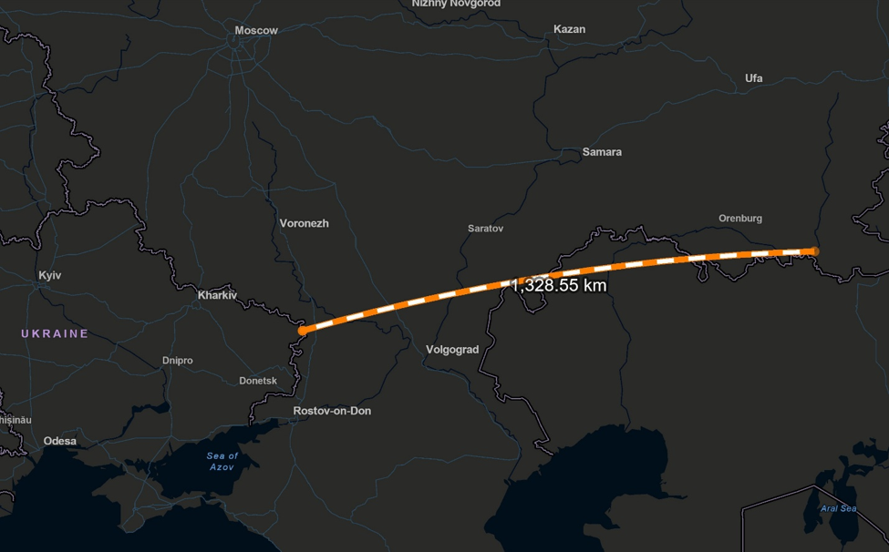
Figure 2: illustration of direct-line distance between Milove, the easternmost extension of Ukraine's internationally recognized territory, and Orsk, Russia, which exceeds approximately 1,300 km (around 1,328 km in a straight-line measurement). However, this distance represents only a theoretical geographic calculation and does not account for operational constraints.
The target area is located near Kazakhstan's border, where additional Russian air-defense coverage may exist. Furthermore, terrain features, including elevated areas, and the occupation of parts of eastern Ukraine significantly affect potential flight routes. If Ukrainian claims regarding a successful drone strike to Orsk region are accurate, the actual flight distance would likely have been greater than the direct measurement due to the need to avoid defended areas, adjust trajectories, and approach the target from a more favorable operational direction.
Figure Source: ArcGIs.com
Persian Gulf Region Case
Thousands of kilometers away, the conflict in the Persian Gulf region, which began in 2026 with U.S. and Israeli strikes on Iran, provides another case study in this context. Iran's successful retaliatory drone strikes against strategic radar sites such as early warning radar sites and other military assets further demonstrated the challenges posed by drones (Beaule, Charalambous &Inal 2026).
This is particularly significant because the theater of the conflict encompasses the territory of both sides, while the Persian Gulf is continuously monitored by U.S.-deployed airborne and ground-based early warning and surveillance assets including Airborne Warning and Control System (AWACS) (Costa, Luetkefend, & Gillespie, 2026) platforms well as the Persian Gulf’s Arab states' Integrated Air and Missile Defense (IAMD) network (Vidal Ribe, 2026), in which they have invested heavily over recent decades.
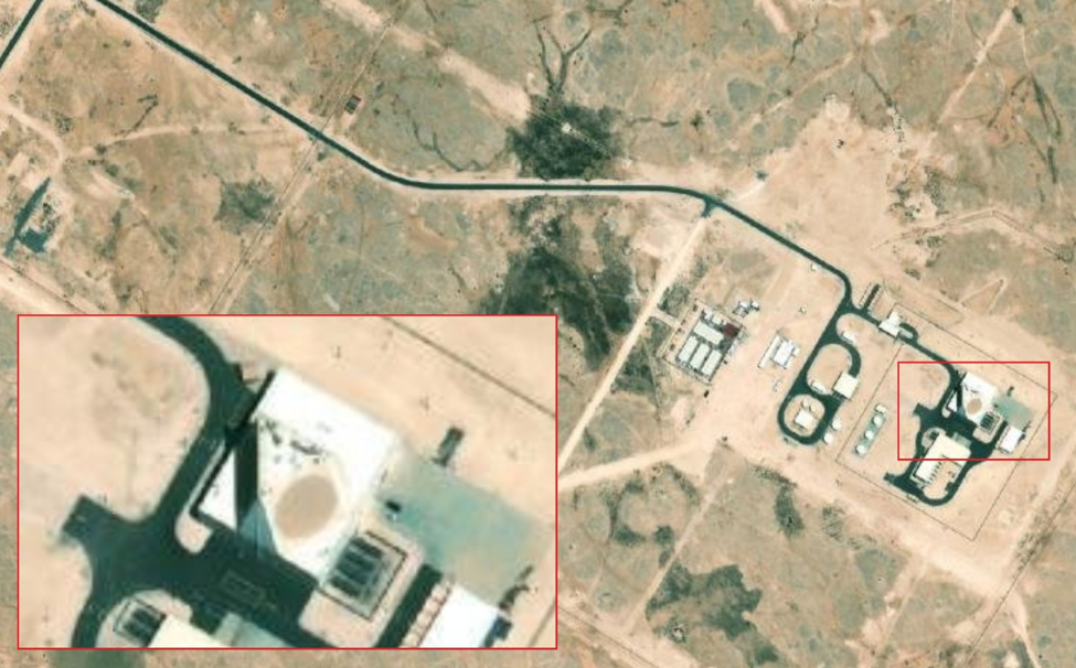
Figure 3: AN/FPS-132 Early Warning Site, located approximately 5 kilometers southwest of Umm Garn Airport, Qatar (Location: 25°42′24.6″N, 51°15′16.6″E). Iran claimed this site successfully has been targeted during the 2026 conflict. The site is approximately 230 km from the nearest point of Iran’s Persian Gulf coastline. The red-highlighted zone extends 180–210 km inland from Iran’s Persian Gulf coastline, measured from the entrance to the Strait of Hormuz, and excludes Iran’s southeastern coastline and the smaller Persian Gulf islands.
The delineation of this zone accounts for terrain elevation and observation advantages provided by mountainous areas. If Iran’s claim is accurate, and in case drone was launched from Iran’s southeastern coastline, the implications would extend beyond Qatar’s air and missile defense (AMD) architecture to the AMD networks of other Persian Gulf states, particularly the United Arab Emirates (UAE).
A successful strike on the AN/FPS-132 Early Warning Site would suggest that Iran can conduct launches from this high-risk area despite regional surveillance and air defense coverage. Figure Source: ArcGIs.com
Conclusion
The evidence from both regions provides valuable lessons regarding the evolving nature of modern warfare. Traditionally, territorial extent has been considered an important factor in assessing military power, strategic advantages, and vulnerabilities. However, the emergence of drone warfare has challenged this conventional assessment by reducing the weight of territorial depth as a decisive advantage or disadvantage.
These cases demonstrate the vulnerability of even highly concentrated and heavily equipped AMD networks, where the concentration of critical defensive assets may increase the risk and probability of penetration. In the event of successful penetration and the destruction or disruption of critical nodes, concentrated networks could face serious challenges, potentially resulting in the loss of significant portions of coverage or a reduction in overall AMD effectiveness.
For countries with greater geographical depth, the increased area of responsibility may create additional gaps and opportunities for penetration, allowing adversaries to approach from unexpected vectors where AMD coverage is limited or ineffective, and complicate the intercepting.
Bibliography
1. Atashjameh, M. (2024, August). Passive defense measures in saving Iran's ballistic missile arsenal. Middle East Studies (MES) Insights, 15(4). Marine Corps University Press. https://www.usmcu.edu/Portals/218/MES%20Insights_Atashjameh_15_4.pdf
2. Atashjameh, M. (2026). Suppression of enemy air defense (SEAD) in Iran's defense doctrine. Strategic Horizons, 2(1), 44–58. Air University Press. https://www.airuniversity.af.edu/Portals/10/Strategic-Horizons/Journals/Volume-2_Issue-1/Strategic-Horizons_Vol-2_No-1.pdf
3. Upton, L. O., & Thurman, L. A. (2000). Radars for the detection and tracking of cruise missiles. Lincoln Laboratory Journal, 12(2), 355–366. Massachusetts Institute of Technology Lincoln Laboratory. https://archive.ll.mit.edu/publications/journal/pdf/vol12_no2/12_2detectcruisemissile.pd
4. Reuters. (2025, July 15). Russian drones, missiles hit Ukrainian cities, officials say. Reuters. https://www.reuters.com/world/russian-drones-missiles-hit-ukrainian-cities-officials-say-2025-07-1
5. Chursina, K. and Safronova, O. (2024) ‘Ukraine claims second hit on Russian missile early-warning radar’, Bloomberg, 27 May.
6. Beaule, V. Charalambous, P. Inal, K. (2026) ‘US and allied radar sites in the Middle East struck at least 10 times: Visual analysis’, ABC News, 18 March.
US and allied radar sites in the Middle East struck at least 10 times: Visual analysis - ABC News
7. Costa, J., Luetkefend, T. and Gillespie, M. (2026) ‘Tracking US military assets in the Iran war’, Atlantic Council.
8. Vidal Ribe, A. (2026) ‘Defending the skies of the arab gulf states’, International Institute for Strategic Studies (IISS), 18 March.